Vilcanota-Urubamba Basin (Peru)
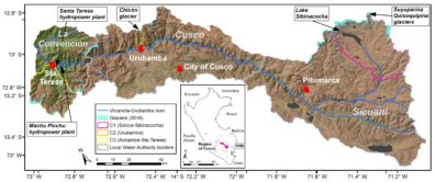
Overview of the VUB with focus catchments, glacier areas, major population centres (in white), and local water authority regions (in grey italics).
The Vilcanota-Urubamba river basin (VUB) is located between the Central and Eastern Andes at the transition towards the Peruvian-Bolivian Altiplano in the region of Cusco, Southern Peru. The basin extends from 5443 m asl. to 1180 m asl. and is characterized by a complex topographic and hydroclimatic setting. It includes outer- and subtropical climatic features with strong westerlies during the pronounced dry season (austral winter) and prevailing easterlies transporting moisture during the wet season (austral summer). The region is particularly influenced by interannual anomalies of El Niño Southern Oscillation (ENSO) with increased easterly moisture transport during El Niño and enhanced dry westerly flow regimes during La Niña.
The VUB is characterized by diverse plant communities which are highly adapted to the extreme environment (e.g. high solar radiation, daily temperature change). Disperse herb and cushion plants dominate the upstream areas (puna) where high-Andean peat wetlands (bofedales) can be found, whereas denser populated shrub and tree vegetation are typical for the inter-Andean valleys further downstream. The VUB covers a total glacier extent of ~142 km² (~6.5 km³) distributed between the Cordillera Vilcanota which holds the second-largest tropical glacier mass in the world, and the Cordilleras Urubamba and Vilcabamba.
For more information, follow this link to the RAHU site.
Country: Peru
State/Region: Cusco
Major Population Centers: Cusco (430,000)
River Length: 400 km
Watershed area: 11,050 km²
Köppen Climate Classification: ET – Cfb – Cwb
Headwater source: Abra La Raya (5443 m asl.)
Mean annual precipitation at source: 826 mm (DJF: 151 mm/month, JJA: 10 mm/month)
River mouth: Santa María (1180m asl.)
Mean annual discharge at river mouth: 133 m³/s (DJF: 322 m³/s, JJA: m³/s)
Mean annual precipitation at mouth: 1145 mm (DJF: 174 mm/month, JJA: 27 mm/month)
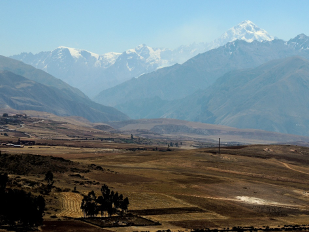
Agriculture in the Sacred Valley (middle VUB), courtesy Fabian Drenkhan.
The basin is home to many peasant communities with traditional livelihoods who depend in a large part on rain-fed and irrigated agriculture, livestock breeding and some traditional manufacture of local products for the region and for export. Low socioeconomic levels combined with the extreme semi-arid environmental conditions, make many people particularly vulnerable towards threats of water scarcity. Hydropower production represents another important and vulnerable water sector in the VUB where currently more than 290 MW of installed capacity downstream depend on headwater resources and water regulation. Many landscape elements are an integral part of the Andean cosmovision. For instance, glaciers are perceived as part of important mountains deities and represent, thus, essential cultural and spiritual values for the indigenous population and frequent pilgrimage activities.
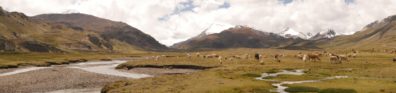
Upper VUB with wetland features (close to Sibinacocha), courtesy Fabian Drenkhan.
Major Issues
The Altiplano region in Peru and Bolivia is naturally characterized by prolonged drought conditions. This situation is exacerbated by strong glacier shrinkage and (seasonal) precipitation reductions associated with impacts from climate change. Future projections in the basin suggest a further aridification of the Altiplano region and a wide reduction of glacier extent within a few decades. Hence, in the upper basin water availability would be seriously affected while increasing demand in the densely populated middle basin exerts further pressure. This situation raises major concerns for long-term water security. Current adaptation strategies to water scarcity mostly focus on the implementation of large reservoirs that – from a technical point of view – might be an efficient measure to store and regulate water. However, the region accounts for a large series of social conflicts on e.g. the construction of new dams and hydropower infrastructure and rooted in low governance and exclusion from decision-making. These water conflicts eventually make new water infrastructure projects socially and economically unfeasible. Therefore, current efforts are put on engaging local communities (e.g. with citizen science projects and policy dialogues), regional governments and water users guided by scientific evidence within an inclusive society-science-policy process.
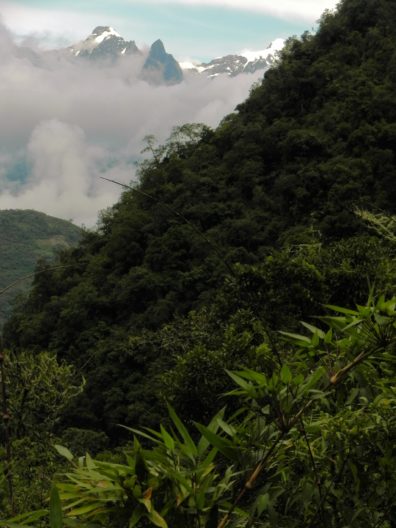
Tropical landscape and glaciers in the Cordillera Vilcabamba (middle-lower VUB), courtesy Fabian Drenkhan.