Tempisque-Bebedero (Costa Rica)
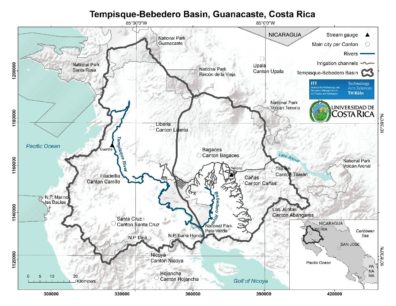
The Guanacaste region in northern Costa Rica has long been an important bridge in Central America for imports and exports of particularly agricultural products. Historically, the main rivers (Tempisque and Bebedero) were used for transportation dating back to pre-Colombian times (Chorotega, Corobici and Aztecan native people inhabited the region). During colonial times, the region, which coincides to almost 40% with the Tempisque-Bebedero catchment system (Map 1) was transformed into a large-scale, hacienda-type cattle farming area. Such a development was based on the deforestation of mainly tropical dry forests and subsequent conversion into pasture in the lower parts of the catchment system. More recent land use transformations mainly since the 1950s have seen an expanding crop production, such as rice, sugar, beans, melon and to a lesser extent coffee (~940km2 of cropland area in 2010 or 28% catchment area). In 2015, 326,953 inhabitants lived in the province of Guanacaste (4,757,606 total or ~7% of the Costa Rican population), which is mainly conformed of rural communities apart from the province capitol Liberia (~57,000 inhabitants) also located within the catchment. The average population density of 32.2 hab/km2 is low compared to the national average of 84.2 hab/km2. The Human Development Index (HDI) for Costa Rica increased from 0.605 in 1980 (50th world ranking) to 0.766 in 2014 (69th world ranking). The Guanacaste province averages an HDI of 0.768 in 2015 with the district of Liberia exhibiting an HDI among the highest of the country (0.839) stating a relatively high quality of life with access to education, health services and economic resources. Currently, the forest cover in the province of Guanacaste is composed of secondary forests and primary dry tropical rainforest. Tree plantations using Teak, Melina and Pochote trees are increasing since the 1980s. The land used for agriculture includes annual, permanent and ornamental crops. In the Tempisque-Bebedero basin the most important crops are sugar cane, melon and rice, which need irrigation.
The Tempisque-Bebedero catchment system is also linked to the country’s largest hydropower project Lake Arenal. Although, situated on the Caribbean slope, water from Lake Arenal is transferred to the Pacific slope Tempisque-Bebedero catchment for hydropower generation and successive irrigation. Lake Arenal contributes around 17% to the national power grid (installed capacity of 157MW).
Major Issues
The area used for crop agriculture (pasture excluded) in the catchment increased from 0% in 1950 to 4.4% in 1974, to 24.7% in 2000 and to 27.8% in 2010. A total of 940km2 was used for crop production in the catchment in 2010 (Figure 1). The pasture areas are mainly used for cattle production and has been a historical factor causing most of the deforestation up to the 1970s. Since the 1980s, forest cover is increasing due to a deforestation ban and environmental protection initiatives, and has experienced a significant increase in land used for agriculture and crops that depend on irrigation. Irrigated agriculture started in the 1970’s with the construction of the first phase of the Tempisque-Arenal Irrigation District (TAID – 60km2) and comprised around 130km2 in 2000. The TAID has currently a total length of 366km of irrigation channels. In the 1980’s, the agricultural model finally shifted from a more subsidence-oriented to an industrial and export-oriented model increasing productivity and diversification. The latter shift was mainly driven by the insertion of Costa Rica into international markets, which culminated in the Free Trade Agreement with the USA in 2009. This, along with the hydropower development has had a noticeable impact on key ecosystems, such as the Palo Verde Wetland National Park affecting the overall water quality and quantity.