Quebrada Grande (Costa Rica)

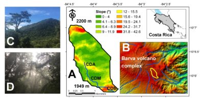
(A) Quebrada Grande (2.6 km2) catchment. Slope (in degrees) is color-coded. The upper-left inset shows the location of study site in central Costa Rica. (B) Quebrada Grande is located within the Barva volcano edifice. The catchment (yellow bold line) drains to the Caribbean basin within a relative complex topography. (C)-(D) Photographs showing the typical aspect of this mixed primary and secondary forested catchment.

Basin Overview

Quebrada Grande is a small (3.9 km2) and mixed primary and secondary forested catchment with minimum anthropogenic activity in the last 100 years. Catchment elevation ranges from 1,765 up to 2,350 m asl with relative steep slopes (up to 40.8°) at the middle of the watershed. The area is part of the Payment for Environmental Services (i.e., payment for forest conservation and ecosystem services) scheme of a local drinking water operator.

Quebrada Grande is categorized as a pre-montane rainforest catchment comprising mostly secondary forest (70-80 years old) with few reminiscences of relict primary forest (>100 years old) within the riparian zones and the highest portion of the catchment). This type of forest is also under the influence of excessive humidity, partially due to the influence of the Caribbean trade winds rainfall regime and strong orographic effects. The canopy reaches 25-30 m in height and intermingles with the middle stratum, which is the product of the large number of epiphytes of different groups (i.e., mosses, ferns, orchids, bromeliads, and ericaceae). The understory is mostly dominated by palms and bamboo.

The rainfall regime in Quebrada Grande is characterized by heavy cumulative rainfall throughout the year (5,117 ± 817) mm. Monthly rainfall ranges from 178 mm (February) to 767 mm (December). Maximum daily rainfall ranges from 31.2 mm to 250.0 mm with an average rainfall intensity of 2.42 mm/min. Mean potential evapotranspiration is 612±43 mm. Ambient temperature ranges between 24.0 and 6.7 °C, with a mean annual value of 15.2 °C. Relatively low temperatures denote the influence of cold fronts between mid-November and February. Relative humidity is consistently high with a mean value of 97%. Overall, the abundant rainfall turns the Quebrada Grande catchment in a highly dynamic system with recurrent high flows, near-saturated soils, and a shallow water table throughout the year.

Storm flows are characterized by large debris and cobbles transported along with a notable yellow/light brown pigmentation of the stream water, due to high dissolved carbon concentrations. Stream temperature fluctuates between 10.4 and 16.8°C, with a mean value of 14.1°C. Quebrada Grande discharge varies from 0.12 m3 s-1 to 6.13 m3 s-1. A cross-correlation analysis between rainfall and stream discharge indicated that storm flows likely occurred on average within ~1.25 hours after the rainfall maxima.

Facts and Figures

Country:  Costa Rica
State: Heredia
Major Population Centers (people in 2017): 138, 562

River Length: 4.0 km
Watershed Area: 3.9 km2
Köppen Climate Classification: Af, tropical rainforest climate

Source: Headwaters at the east flank of the Barva volcano edifice
Mean annual precipitation: 5,117 ± 817 mm
Mean annual discharge at mouth: 3,593 ± 1,001 mm

People and Land Use

Quebrada Grande is a high elevation and small watershed providing multiple ecosystem services. Future plans for water allocations from this watershed include uses as drinking water and hydropower generation; however, since this watershed is inserted in the Braulio Carrillo National Park, these potential plans are still restricted and are under study.

Major Issues

The main challenge in this region is the expansion of residential and agricultural lands.

Research Ideas/Topics:

  • Does rainfall seasonality exert the main control over dissolved organic matter (fluorescence and concentration approach) export and transport in a dynamic and small high elevation tropical watershed?
  • To what extent vegetation prefers (water stable isotope-inferred approach) the use of shallow or deep water sources in a dynamic and small high elevation tropical watershed?
  • What factors control concentration-discharge relationships (i.e., dilution, chemostasis, mobilization of trace elements) in a dynamic and small high elevation tropical watershed?