Corumbatai River (Brazil)
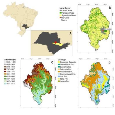
Major land use in the basin is related to agriculture, that represents 79% of the total area. Only 17% of the total area is occupied by forested areas and 4% by urban zones. The main agricultural product is sugar cane, that represent the most important economic activity in the basin followed by mining activity to supply the ceramic pole located in Santa Gertrudes.
Major Issues
Demand for water resources to supply urban areas is more than 95% of the total water extracted from the Corumbataí river. The volume extracted surplus the total water availability (less than 1,500 m3.hab-1.year-1) and the tendency for the future is an increase in water demand to support the economic development of the basin. This increase in water demand tends to be supported by groundwater, and wells have been drilled to supply water for private users, without a knowledge about groundwater availability in the basin and specific management policies. Another issue is related to the protection of the Guarani Aquifer System recharge areas against pollution sources associated to agricultural practices and impacts related to climate changes, since recent intense droughts have impacted negatively in water availability.
Research Questions:
- How does recent and past industrial development and urbanization processes impact on the urban hydrological cycle? Can these impacts be tracked using stable isotopes or different environmental tracers?
- What is the extent of the recent uncontrolled increase in groundwater extraction in the watershed on water availability? Establishment of groundwater conceptual models using multiple tracers (geochemical evolution and dating tracers)
- What is the spatial-temporal variability of isotopic composition of rainfall (high spatial and temporal sampling procedures)
Skillset: Physical hydrology, isotopes, geospatial analyses.