Atuel-Chadileuvú River (Argentina)
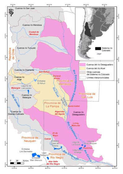
General Alvear (Mendoza) is the main city with 28,000 inhabitants. Towns in La Pampa are much less populated — Santa Isabel with 3,000 and Algarrobo del Águila with just 1,000.
Major landowners in the basin are private companies and individuals. Many large estates have little water that is limited to livestock drinking purposes. Irrigated lands are highly fragmented (80% of the farms are less than 10 hectares). 50% of the cultivated land is orchards, 25% vineyards, 10% irrigated pastures and 6% fresh vegetables.
Major Issues
The Atuel River has been heavily modified to support irrigated agriculture first and hydropower secondarily. Modifications include four dams and hundreds of kilometers of irrigation canals, diversions and drains. Recently with the reduction of water flows and the intensification of the hydrological cycle the basin has been facing droughts with consequences for agriculture, tourism and hydropower generation. The competition among these three main uses reveals a clear water-food-energy nexus.
Additionally, the long-standing interstate conflict between Mendoza and La Pampa provinces over the allocation and distribution of water has reached the national level in both judicial (Supreme Court) and political spheres (interstate political tension). Finally, new water-demanding activities, like mining and fracking are increasingly threatening traditional water uses and users.
Research Ideas
- To what extent, and how, are different water uses (agriculture, hydropower, tourism and recreation, and fracking) interrelated in water-resource (volume) terms and institutionally (use rights)?
- River flows have been declining historically. How has this compromised or affected the water security of the various users?
- Water has been managed under a very old law with strong institutional inertia. What are the main current weaknesses and challenges faced for an institutional transformation towards water security?