Rio Frio (Colombia)
The Río Frío watershed is located on the southwestern slopes of the Sierra Nevada de Santa, a coastal mountain massif in the Caribbean region of Colombia. The watershed covers an area of ~300 km2, with elevation ranging between 30 to ~4,000 m.asl. After ~45 km, the river exits the massif and flows into the lowlands where most of its discharge is diverted for an irrigation district. Annual precipitation varies with elevation, with 1,000 mm/year in the lowlands, to ~2,700 mm/year at 2,200 m.asl. There is also large intra-annual rainfall seasonality with a marked dry season from December through March which transitions into a wet season from May through November with a short drier season or “veranillo” from mid-June through mid-August. Interannual rainfall and discharge variability are related to several ocean-atmosphere oscillations, including El Niño/Southern Oscillation (ENSO), the Tropical North Atlantic index (TNA), the Atlantic Meridional Oscillation (AMO) and Pacific Decadal Oscillation (PDO). Annual mean temperature at sea level is 28°C and decreases to 14°C at 2,200 m.asl.
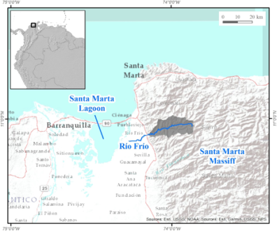
View from Sierra Nevada de Santa Marta (foreground) surrounded by the lowlands, Santa Marta Lagoon and Caribbean Sea on the background (photo by E. Trujillo, Universidad del Norte).
Country: Colombia
State/Region: Magdalena/Sierra Nevada de Santa Marta
Major Population Centers (people in 2018): Santa Marta (480,000), Ciénaga (120,000)
River Length: 45 km
Watershed area: 300 km2
Köppen Climate Classification: Aw (Equatorial winter dry) and Am (Equatorial monsoonal)
Headwater source: Páramo on the western flank of the Sierra Nevada de Santa Marta, where Pico Cristóbal Colón, at 5,700 m.asl, stands as the highest mountain in Colombia and one of the highest coastal ranges in the world.
Mean annual precipitation at source: ~1,500-2,000 mm (estimated, there are no rain gauges above 2,200 m.asl; the river source is at ~4,000 m.asl).
River mouth: Ciénaga de El Chino (El Chino coastal lagoon, part of the Santa Marta lagoon system)
Mean annual discharge at river mouth: varies seasonally from 5.6 m3/s (January-April) to 21.4 m3/s (August-November)
Mean annual precipitation at mouth: 1,000 mm/year
Current land use/land cover in the basin is the result of dynamic social and economic processes that have taken place since colonial times. Land above ~3,100 m.asl is mostly in paramo grasslands. Above ~ 2,100 m.asl, indigenous communities exercise significant control over land use and management. The upper basin is mostly forested, with interspersed pasture patches. Forest successional state is diverse due to multiple factors such as clearing, which started at least since the 1950s by colonos from the central Colombian Andes, and cultivation of illegal crops, particularly marihuana in the 1970s. Medium elevations are dominated by coffee plantations interspersed with annual crops and secondary growth. Coffee expansion took place through the 1940s and 1950s, with the arrival of peasants fleeing from political violence in the central Andes. Lower elevations are covered by a mosaic of pasture, secondary growth, dry forest and annual crops. The flat lowlands are covered by large banana and oil palm plantations.
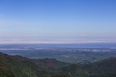
 Mosaic of shade grown coffee, riparian forests, pasture, secondary growth and annual crops in the Río Frío watershed (photo by P. Sepúlveda).
Major Issues
This watershed, and the region as a whole, faces some important water-related challenges. Multiple stakeholders have conflicting interests, including indigenous communities in the paramo, upland small-scale coffee growers and rural inhabitants, and lowland agro-industrial users. Further north, water from the the sierra rivers is also used by urban users from Ciénaga and Santa Marta, and by a growing tourism industry. In addition, fishing communities in the lowlands are affected by diminished freshwater inputs into the coastal lagoon system. Climate projections for the region show contradictory results for precipitation, with predictions for the 2011–2040 period ranging from 10–40% increase to 20–40% decrease relative to historic data (reports from the National Environmental Institute IDEAM). Historical records show mixed results for trends in discharge and precipitation, and an overall increase in temperature of 0.3°C to 0.5°C per decade.