Rio Chama (USA)

Basin Overview

The Rio Chama is a headwater dependent river in the southwestern US, specifically northern New Mexico and southern Colorado.  It is fed by indigenous headwaters in northern New Mexico as well as by the Colorado River whose headwaters come from spring meltwaters from Rocky Mountains snowpack.  Land cover in the watershed is primarily forest and high montane vegetation, with some shrubland/grassland and agricultural development.  The watershed covers stretches from the San Juan mountains in Colorado to the Rio Chama’s confluence with the Rio Grande near Española.  The watershed has a steep slope, dropping nearly 600 m in elevation from the headwaters to the river’s mouth.  Climate characteristics vary drastically along the river, with much higher precipitation and much lower temperatures in the northern part of the watershed.

People and Land Use

The Rio Chama serves rural and urban populations throughout Rio Arriba County and indirectly also serves the Rio Grande Valley as its waters flow through the Rio Grande below the confluence.  Farmers and ranchers are often at the center of water debates in the region, as farmland occupies approximately 5,700 km2 of the 15,270 km2 county.  The Rio Chama also serves the Jicarilla Apache reservation.  Federal, state, and local agencies manage dams along the river which store water and produce 20.6 MW of hydropower.


Facts and Figures

Country:  United States
State: New Mexico
Major Population Centers (people in 2018):  In New Mexico: Albuquerque (560,218), Las Cruces (102,926), Santa Fe (84,612).  Along Rio Chama: Española (10,050), Ohkay Owingeh (1,480)

River Length: 169 km
Watershed Area: 8,179 km2
Köppen Climate Classification: warm-summer humid continental

Source: Indigenous headwaters at Chama; additional headwater source in the Rocky Mountains
Mean annual precipitation: 54.6 cm/year at Chama, 35.6 cm/year in Rocky Mountain Nat’l Park

Mouth: Rio Chama
Mean annual precipitation: 24.4 cm/yr
Mean annual discharge at mouth: 12.2 m3/s

Major Issues

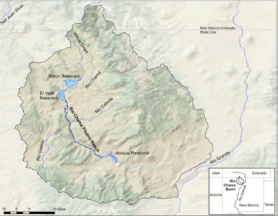
The main water challenges facing the Rio Chama are particular combinations of changing physical conditions and human interventions.  Hydrology in the watershed has changed significantly as a result of the construction of dams for hydropower generation and flood mitigation.  An overarching concern is the Rio Grande Compact, which requires a certain amount of water from the Rio Chama to enter the Rio Grande in order to provide water to users all the way down the river.  Several conflicting governance priorities complicate water management strategies throughout the watershed.  Climate change has also altered the timing and quantity of water flowing through the river.  One of the primary manifestations of these complex issues is the “flattening” of the hydrograph: dams have reduced flood peaks and rising temperatures have shifted the timing of high snowmelt-driven flows to earlier in spring.