Nevados Del Chillán (Chile)
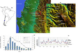
The Nevados del Chillán Volcanic Complex (Figure 1), provide the ideal study site to further study mountain hydrology, their headwater dependent systems and its relationship with social-water dependent communities. Mountains and its groundwater contribute significant amount of baseflow as well as provides storage to its surrounding river which supports the minimum flows, ecosystem services. Mountainous topography and its riverine systems are ideal hydrological systems to provide services such as water resources for consumption, energy and irrigation among other services. Local communities are therefore adapted to such systems, and are in constant use of such services.
The selected study area is viewed and ideal site for studying and further understanding all the phenomenon related with surface water, groundwater processes of a mountainous system and its relations with social water-dependent systems. The Nevados del Chillán volcanic complex provides two different and contrasting states interesting to be studied. On one hand, the western slope of the volcano (the Diguillín, Renegado and Chillán river basins) is highly intervened by touristic developments and by the real estate industry, while the eastern slope (the Río Ñuble and Los Sauces rivers) remains almost unaltered. Social mapping and quantitative measures are needed to very contrasting areas. Moreover, at Ñuble river, an ongoing project for developing a dam for irrigation and energy purposes which, if is built, might change the way the population interact with the HDS.
The Nevados del Chillán, is a volcanic complex composed by two volcanoes: Nevados del Chillán and Volcan Chillán ), that share a 12 km long geological fail which runs from north to south. Relevant glaciers are located at the west side draining to the Chillán River and at the east side draining to the Ñuble River (Figure 1c)
This study site is focused on the importance of a HDS in which volcanic systems are a key component for resilience under climate change and variability. Therefore, to perform the study, a non-highly altered volcanic system and with availability of data is needed. Current information initial studies about the importance of a HDS such as the proposed study site is already developed in the area (e.g. Arumí et al., 2012, Arumí et al., 2014, Arumi et al., 2014b, Muñoz et al., 2016), providing a base of knowledge to further investigate the Nevados del Chillán volcanic system and it social-water relationships.
Studying the Nevados del Chillán volcanic complex will encompass data processing and model simulations as well as a fieldwork to understand the volcanic system, to collect and acquire data and to map the social local communities around the volcano.
Country: Chile
State/Region: Ñuble
Major Population Centers (name and population size): Chillán (260.000); San Carlos (55000), Bulnes (22000), San Fabián de Alico (1500)
Headwater source: Nevados del Chillán Volcanic Complex
Mean annual precipitation at source: 2500 mm/year
Köppen Climate Classification: Warm Temperate
Rivers that drain the Volcanic Complex
| River | Gauging station | Watershed area
km2 |
Mean annual discharge
m3/s |
Length
Km |
| Ñuble | Los Sauces
Ñuble en La Punilla Ñuble en San Fabian |
606
1251 1645 |
30.8
73.5 91.5 |
70 |
| Chillan | Chillán en Esperanza | 167 | 12 | 23 |
| Renegado | Renegado en Invernada | 128 | 0.99 | 23 |
| Diguillin | Diguillín en San Lorenzo | 204 | 14.4 | 28 |
Those rivers reach the Itata River, that had a mean annual discharge of 196 m3/s
At the area surrounding the Volcanic complex, land cover changes have been driven by an increase in income levels, which has led to significant growth in second home construction. At the Renegado watershed area, as it is a major tourism center based on skiing and hot springs. There are now more than 1000 vacation houses and several resorts that have been constructed on the more than 5000 small parcels that are available in the area. This explosive increase in construction has taken place without any planning or control, as the area is considered rural land.
From the other side of the system, beside the Ñuble river are settled a few small mountainous behaved towns. The largest one is the San Fabián de Alico with a population of ~1500 people. People in that area is accostumed to live with the river and uses the services the river provide. They are close to the limit with Argentina and their animal are fed in the highest areas of the mountains (the veranadas). Currently along the Ñuble river up to San Fabián de Alico does not exist major industrial and disruptive developments and are integrated with the river’s natural processes and variability.
Major Issues
According to Chilean law, disposal of waste water from small houses located in rural areas should be carried out through the use of septic tanks. With the extensive use of septic tanks, located above the highly permeable soils that overlie the fractured rock aquifer, there is a concern that water quality in the Diguillín River could be impacted by housing and tourism development. Pollutants from the wastewater disposal systems will move through the fractured rock network and discharge into the springs that are used as drinking water sources for the houses and communities that are located down gradient.
Currently there exists a big dam project to be built in the Ñuble river, upstream of San Fabián de Alico to provide of summer high flows downstream for irrigation. An ongoing conflict between the people upstream and downstream of the river is occurring because the impacts/benefits of such type of project.
Research Questions:
- How a HDS with two marked social dependence will be affected under the current climate change and variability scenarios?
- Although the same source (the Nevados del Chillán system) is being affected by climate change and variability, how does the communities will be affected?
- How a change such as the Punilla dam in the Ñuble river might change the human-water interaction? And how the ecosystem services will be affected?
- What are the impacts of the human use of HDS on surface and groundwater quality
Other specific questions
- Does the volcanic aquifer of the Chillán volcanic system release proportionally more water to some rivers than to others?
- What impact would have land use change and climate change on the water quality of the springs that are used for drinking water, irrigation and ecosystem support?
- Does the human use of headwater systems impacts the groundwater quality downstream?