Laja River (Chile)
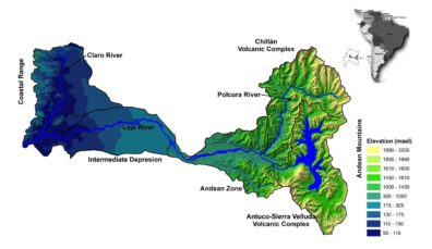
The Laja river basin covers an area of 4668 km2, is located in the mountainous and temperate Andean zone of south-central Chile (Figure 1) and is bounded to the east and west by the Andes (Andean mountains) and Cordillera de la Costa (coastal range), and to the north and south by the volcanic complexes of Chillán and Antuco-Sierra Velluda, respectively.
This area is highly impacted by El Niño Southern Oscillation Phenomenon (ENSO). ENSO is a coupled ocean-atmosphere phenomenon characterized by irregular fluctuations (2–7 years periodicity). In the study area, the alternation of El Niño – La Niña events is the major source of inter-annual variability where El Niño/La Niña episodes are associated with above/below precipitations and warmer/colder than normal air temperatures.
Country: Chile
Region: Biobío
Major Population Centers (people in 2018): Los Angeles (20,200); Antuco (4,000), Yumbel (22,000), San Rosendo (3,400) y Laja (22,400)
River Length: 140 km
Watershed Area: 4,668 km2
Köppen Climate Classification: Warm Temperate
Source: Laja Lake
Mean annual precipitation: 2500 mm/year
Mouth: Biobio River
Mean annual precipitation: 1500 mm/year
Mean annual discharge at mouth: 145 m3/s
At the basin’s headwaters is the Laja Lake sub-basin which correspond to a depression of volcanic soils of low permeability (Thiele et al., 1998) in the Andes. The topography is dominated by steep slopes while the and plains with soil types divided among sandy soils and silty soils (Kasargodu). The Lake basin’s soils are composed of volcanic and sandy soils. Agricultural, urban, and industrial water demands are distributed for users through water rights that guarantee flow rates to different users. From the lake basin are two main outputs: i) the Lake discharge (natural) through fractured rocks which forms the origins of the Laja river, and ii) the El Toro Hydroelectric Plant (anthropogenic) which controls the outflows from the lake according to energy and irrigation demands.
Major Issues
Laja Lake is located in the Chilean Andes at 1360 m. a. s. l., next to Antuco Volcano in the west and in the Biobío basin. The lake has an area of 87 km² and is located between 36° 50’ and 37° 40’ S and 71° 7’ and 72° 45’ W (Mardones & Vargas 2005). The Laja River is the main tributary of the Biobío River and springs from seepages through the barrier made up of volcanic material that dams the lake and is the source of water that supplies almost two million inhabitants of the Biobío Region, seven hydropower plants, with 1150 MW of installed capacity, and almost 120,000 hectares of irrigation.
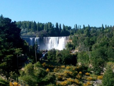
During the last decade, water resources management in the Laja system has become a critical matter due to a long period of water scarcity that has affected Chile, as well as increased citizen sensitivity to the protection of landscapes and ecosystem services, for which Laja Falls has become a central icon. All of this has given rise to a series of research and consulting projects on the Laja basin and the management of the system.
Components of the Laja Basin
Based on the morphological and geological aspects of the Laja basin, it can be divided into four main zones as follows:
 The Laja Lake: Is located at the western slope of the Andean mountains (860 – 3550 masl), over a depression of volcanic soils. The Laja Lake plays an important role in the water storage and regulation. Regulates (stores) the water during high rain periods to be delivered during the dry (summer) season. This is a key aspect for the activities developed downstream where the agriculture is the main activity which demands high summer flows. Furthermore, Laja Lake, together with its contributing area, covers roughly 21% of the total basin area, and is highly, even totally, influenced by the snow-glacier component, and therefore offers an important source of snow storage.
- The Andean Zone: It covers the area from the contraction in the middle of the basin to the Andean peaks at the Polcura River (the upper north river), its elevation ranges from 289 to 3534 masl. The upper side of this area (the Polcura River basin) is an Andean area where the orography is enhanced. The soils are composed of sedimentary and plutonic rocks, over which there are volcanic and volcano-clastic deposits from the Antuco-Sierra Velluda volcanic complex. It presents low permeability soil layers, high slopes and a significant snow-melt and rain regime. The lower part of this zone is the pre-Andean area, where the orographic effects appears, but is smaller than in the Andean area. The soil is composed mainly of volcanic rocks and granular deposits soil layers, with medium slopes and with a snow-rain regime governed by the high altitudes of the Antuco volcano.
 The Intermediate Depression: It is the area covering the middle of the basin until the junction with the Biobio River which is at the basin outlet (excludes the Claro River basin located at the western side of the basin with the river in North-South direction). This area is composed by a large alluvial deposit called Cono de Arenas Negras del Laja (Laja black sands cone) (100 to 300 masl) located over a lahar formation (low permeability layer) which ends at contact with the coastal range (western limit of the basin). The combination of the sand and lahar deposit yields a permeable soil layer over an impermeable base which promotes the creation and maintenance of groundwater flows and reserves in the central depression. At this altitude, the snow-melting processes become negligible, while the direct runoff and groundwater flows become the most important hydrological processes in the stream-flows generation.
- The Claro River: This is a particular area in the Laja basin, mainly due to the interaction of alluvial deposits with the impermeable barrier of granite in the coastal range (eastern and western side of the Claro River respectively). This interaction produces a north-south orientation of the river, transversal to the typical orientation of Chilean rivers from the Andes to the Pacific Ocean (east-west). Furthermore, the alluvial deposits are governed by gentle slopes (0.3 – 0.8%) with a high permeability soil layer (sand) where the main activity is agriculture. On the other hand, the coastal range presents steeper slopes (> 1%) and an impervious soil layer where forestry prevails. The Claro River and the intermediate depression areas are almost totally used for agriculture. There is a dense irrigation canal network which takes the water from the middle of the Laja basin (in the narrowing point) to be distributed in both, the Laja river basin and in neighboring basins such as the Itata and Diguillín among other river basins.