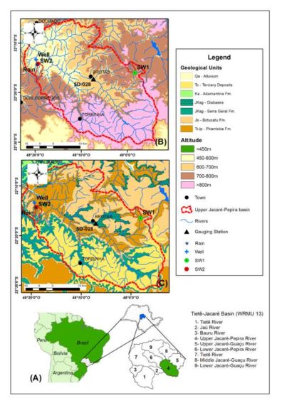
Jacaré Pepira Basin (Brazil)
Total population living in the Jacaré Pepira basin is about 140,000 inhabitants, mostly in small cities (less than 25,000 inhabitants), that relies in groundwater for their water supply. Major land use in the basin is associated to agriculture (sugar cane, orange, reforestation and pasture), and the most relevant industrial activities are directly related to the agriculture production, such as sugar and alcohol industry, followed by sand mining, foundry and vegetable oils refining. The Jacaré Pepira basin has more than 20% of its area occupied by native vegetation, that associated to the existence of water falls in the rivers and the landscape, are responsible for sustaining an important economic touristic activity.
Major Issues
Jacaré Pepira river drains sandstones from Guarani Aquifer System and the protection of the of these areas against pollution sources and modification in soils uses associated to agricultural practices represent one of the most important issues to warrantee water quality and quantity for recharge and maintenance of river flows during dry season. The basin has recently experienced impacts related to climate changes, intense droughts have impacted negatively in water availability.
Research Questions:
- How does rainfall seasonality and related isotopic composition variability exert controls on groundwater recharge, and how this signal can be used to track water exchanges between surface and groundwater?
- How does recent changes in land use (coverage) and agricultural practices impact on water quality (surface and groundwater)?
- Estimation of mean residence times of groundwater in shallow portion of the Guarani Aquifer System using dating tracers (3H/3He)
Skillset: Physical hydrology, isotopes, geospatial analyses.